Home > Apps > Personalization > Avia Maps Aeronautical Charts

Key Features of Avia Maps:
> Unrivaled Aviation Mapping: Reliable and user-friendly aviation maps for global flight planning and navigation.
> Offline Data Access: Download data for any 5x5 degree area on Earth for use in areas with limited or no connectivity.
> Extensive Airport & Airspace Data: Access detailed information on over 65,000 airports, 9,000 navaids, and 15,000 waypoints worldwide, plus airspaces for 62 countries (excluding Antarctica).
> Global High-Resolution Weather: View detailed weather layers (cloud cover, ceiling, precipitation, wind) from sources like DWD and NOAA, all downloadable for offline use.
> Integrated Traffic Information: Enhance flight safety with real-time traffic data integration from ADS-B receivers or the SafeSky app.
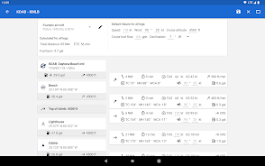
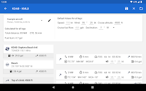
> Precise Performance Calculations: Create and utilize multiple aircraft profiles for accurate route calculations, considering engine type and fuel burn.
Experience the Difference:
Avia Maps Aeronautical Charts is the ultimate tool for pilots and aviation enthusiasts seeking comprehensive, reliable, and convenient flight planning and navigation. Its offline capabilities, extensive database, and safety features ensure a safer and more efficient flight experience. Download Avia Maps today and take to the skies with confidence!
Additional Game Information
Latest Version3.12.2 |
Category |
Requires AndroidAndroid 5.1 or later |
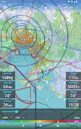
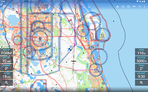
Avia Maps Aeronautical Charts Screenshots


Trending apps
-

- Shopee TW
- 4.2 Photography
- Shopee TW, the Taiwanese branch of the popular Shopee e-commerce platform, provides a vast selection of goods encompassing electronics, apparel, home furnishings, and beauty products. Users can explore diverse categories, benefit from exclusive promotions, and participate in flash sales. The platf
-

- Gradient: AI Photo Editor
- 4 Photography
- Welcome to Gradient: AI Photo Editor, the ultimate app designed to unleash your creativity and transform your photos and videos in ways you never imagined. Powered by state-of-the-art AI technology, our app provides a wide range of innovative features that will both amaze and inspire you. Discover y
-

- TrackChecker Mobile
- 4.4 Photography
- TrackChecker Mobile isn’t just another parcel tracking app—it’s a complete transformation in how you monitor your packages. With support for over 600 postal and courier services worldwide, TrackMaster ensures that no matter where your package is headed, you're always in the loop. Whether it's naviga
-

- Duolingo
- 4.3 Education
- The **Duolingo APK**, developed by Duolingo Inc., stands as a premier choice for language learning, transforming your Android device into a hub of linguistic diversity. Directly accessible through Google Play, Duolingo offers an interactive learning experience tailored to the dynamic lifestyles of t
-

- Free VPN by Getbehind.me
- 4.5 Lifestyle
- Unlock online freedom and security with Getbehind.me's Free VPN. This innovative app offers seamless, secure browsing without registration fees or complicated sign-ups. Prioritizing your privacy, it encrypts all internet traffic, shielding your sensitive information from online threats. Easily cir
-

- Mobile Printer: Print & Scan
- 4.4 Tools
- Discover the ultimate solution for all your printing needs with Mobile Printer: Print & Scan. Whether you're at home, in the office, or on the move, this versatile app empowers you to print documents, PDFs, bills, receipts, boarding passes, and even photos and web pages with ease. Compatible with a
Latest APP
-

- Best Heart Theme HD
- 4 Personalization
- Transform your phone's look with the Best Heart Theme HD app! This exclusive theme is made for those who want their device to truly stand out. Featuring breathtaking HD wallpapers and matching icons created by top designers, your phone will shine in
-

- Lulubox
- 4 Personalization
- Lulubox is a dedicated game management tool for Android, designed to help users organize their games, applications, and other gaming-related elements. It acts as a powerful resource for passionate gamers looking to upgrade their play with patches, m
-

- 3839
- 4.4 Personalization
- 3839 Game Box: Your Gateway to Asian Mobile Gaming 3839 Game Box, also known as Hao You Kuai Bao, is a leading Android mobile gaming platform developed by Xiamen Chunyou Interactive Technology Co., Ltd. It delivers a rich selection of games across ge
-

- Popsicle Galaxy Theme
- 4.2 Personalization
- Turn your phone into a magical galaxy wonderland with the Popsicle Galaxy Theme! Explore the mysteries of outer space as you personalize your wallpaper and icons using this free, user-friendly customization app. Choose from more than 1,000 themes to
-

- Love Island
- 4.2 Personalization
- Join the excitement and romance of the hit reality show Love Island with the official app! Keep up with every dramatic moment and key decision by downloading the free app. Vote for your favorite couple, take part in quizzes and polls, and influence
-

- Talkie: Personalized AI Chats
- 4.5 Personalization
- Talkie: Personalized AI Chats is a revolutionary AI-native platform that empowers users to design, customize, and interact with millions of lifelike AI characters in a dynamic, community-driven environment. Leveraging state-of-the-art generative AI technology, Talkie enables you to craft unique "the
-

- Lottery Ticket Scanner
- 4.1 Personalization
- Lottery Ticket Scanner redefines how you check your lottery tickets, bringing the entire process into the digital age. Skip the drive to the store and the long lines just to see if you've won. With this innovative app, simply download it, choose your
-

- Riyadh As Saliheen French
- 4.2 Personalization
- Embark on a spiritual journey through the vast world of Islamic teachings with the Riyadh As Saliheen French app. This essential tool is tailored for French speakers seeking to enrich their understanding of Islamic principles. Featuring over 1,900 ca
-

- Rugby Manager
- 4 Personalization
- Experience the excitement of becoming a rugby manager and guide your team to glory with this engaging simulation app! Build your dream squad from scratch, develop players into champions, and craft unbeatable tactics to dominate every tournament. Tes